Sugar Sun series location #11: Manila Port

Manila-map-1902
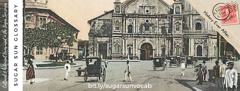
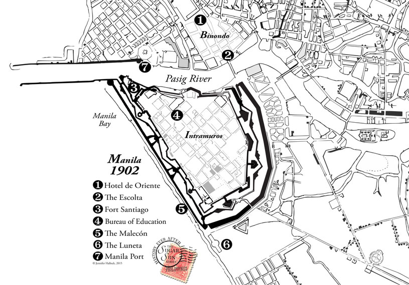
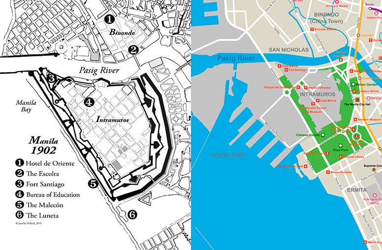
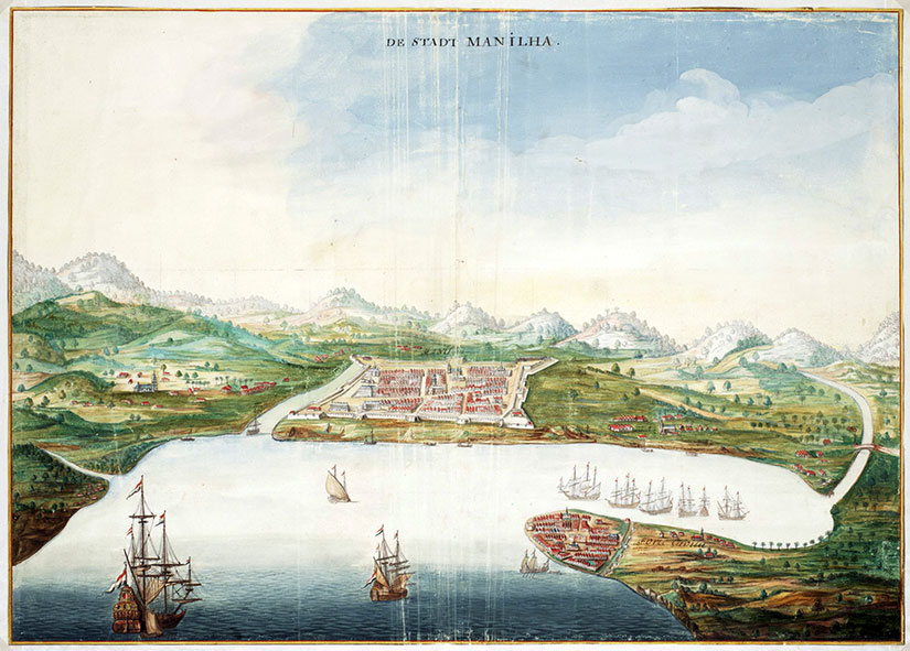
Have you heard romantic stories of evenings strolling on the Luneta, once upon a time? Or racing along the Malecón? Did you wonder where these entertainments took place? Maybe all you know is the enormous port that eats up Manila’s shoreline. If you look at the 1902 map above, though, you will see that port is not there. Not yet.

North shore of the Pasig River
North shore of the Pasig River. Photograph in the public domain and archived with the University of Michigan, Philippine Photographs Digital Archive.

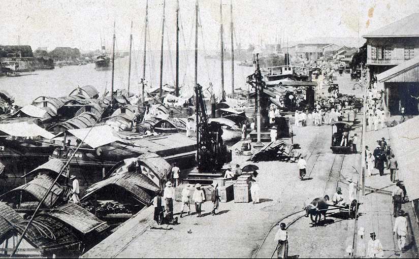
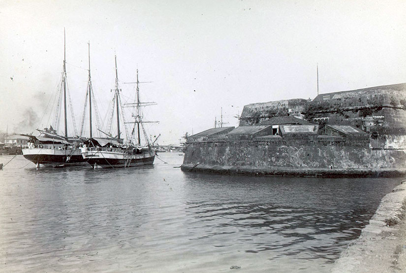
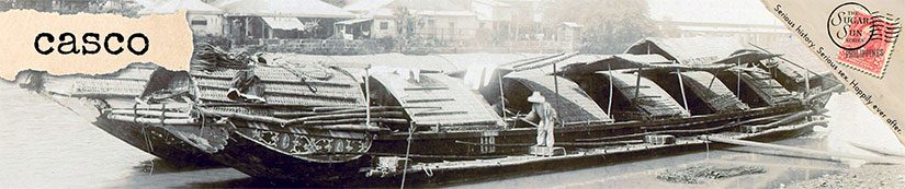
Before 1908, a visitor’s steamship would anchor two miles offshore in the rough seas of Manila Bay. The passenger would transfer to a lighter, known as a casco, and ride with their luggage into the city this way:

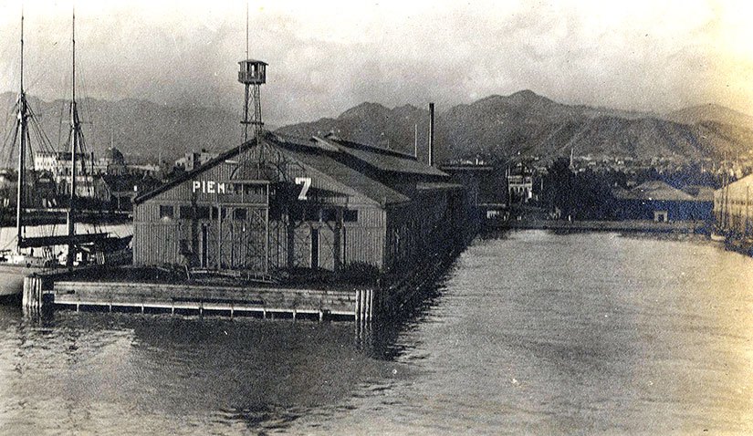
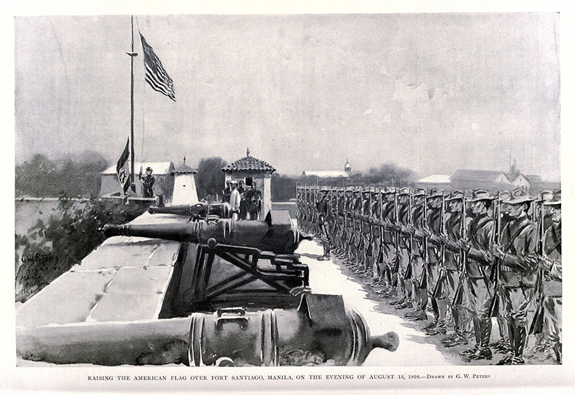
[Della’s boat] pulled past a large fort flying the American flag and headed into the mouth of the Pasig, a river as wide as the Potomac but ten times as crowded. Bossy American steamers, lighters heavy with food and livestock, outrigger fishing boats, and single-man canoes fought upstream for a space at the north-side dock. Her boat won a place and tied up in front of a huge warehouse marked Produce Depot.

Hotel Oriente

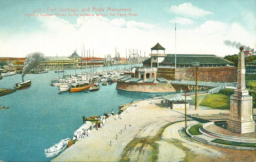
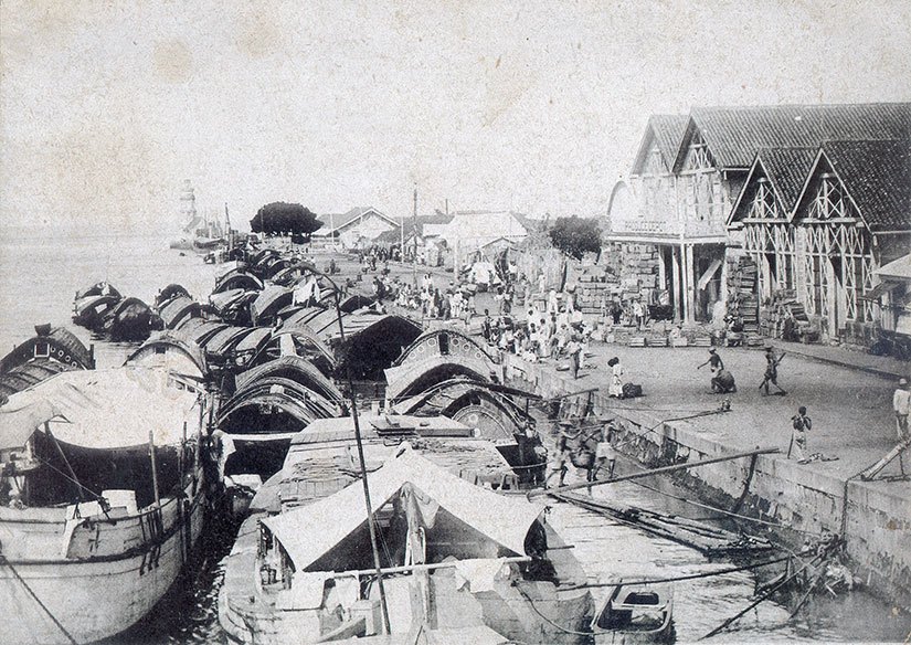
This original port was on the north shore of the Pasig: in front of the San Nicolas fire station and across the river from Fort Santiago. The Yankees did not like this lighter system, though, because they thought it was dangerous and inefficient. Something had to be done, they said. Hence, one of the first major infrastructure projects of the new century was born. (The other from this time was the Benguet Road to Baguio.)

Between 1903 and 1908, the Americans would add 200 acres to the shoreline through land reclamation. The breakwater was expanded, and numbered piers lined the bay.

It was supposed to cost $2.15 million, and certainly no more than $3 million, but—as with all infrastructure boondoggles—it ran to $4 million before the construction was over. (That is $108.4 million in 2016 dollars.) Compared to Boston’s $24.3 billion for the Big Dig (a highway and tunnel project), you still might say that Manila port was a bargain. But before you believe this an example of American largesse, remember that all expenses of the Philippine Commission were paid from local tax revenues.

Moreover, the real cost would be paid by the Filipino families who used to enjoy a safe, leisurely promenade on the beach. At what expense, progress?

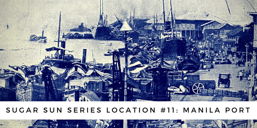
(This post was originally published on the outstanding website, Filipinas Nostalgia, where I will be a guest contributor. Photographs from the Philippine Photographs Digital Archive at the University of Michigan Ann Arbor.)

Sugar Sun series location #10: Fort Santiago

Manila-map-1902

Georgina looked up at Fort Santiago, the stone embodiment of Spanish paranoia that capped the fortress city of old Manila. A bas-relief of Saint James the Moor-Slayer stood guard over the gate. Not the most observant Catholic, Georgie liked the thought of Iberian explorers braving the long, lonely journey across the Pacific only to find themselves back where they started: fighting Muslims. Judging by the number of churches they left behind, conversion had been a spiritual test they had met with gusto.

Under the Sugar Sun

Front gate of Intramuros with Saint James the Moorslayer
Saint James the Moorslayer, a close up of the main gate to Fort Santiago. Creative Commons photo by John Tewell.

The defensive embankment of Fort Santiago (“Saint James”) has been around since shortly after the Spanish took Manila from its indigenous Muslim rajahs in 1571—hence, the tone-deaf dedication to Saint James the Moorslayer. (The Spanish converted or chased out most Muslims in the archipelago, but not all. Still today, 5% of Filipinos are Muslim, mostly in southern Mindanao and the surrounding islands.)

1665 view of Maynila from the bay
A bird’s eye view of Manila by Johannes Vingboons, painted in 1665.

When a Dutch traveler painted Manila in 1665, you can already see the walled city of Intramuros, capped by Fort Santiago at the mouth of the Pasig River. This was where the Spanish Army was headquartered, and it will be the Americans’ choice, too. Almost 240 years later, my heroine Georgina Potter had no choice but to search for her missing soldier brother at Fort Santiago. (The relatively brief US stewardship may be the only time this citadel was not a fortress of Catholicism.)

American flag illustration over Fort Santiago after Battle of Manila 1898
Raising the American flag over Fort Santiago, Manila, on the evening of August 13, 1898. From Harper’s Pictorial History of the War with Spain, Vol. II, published by Harper and Brothers in 1899.

Through the eighteenth and nineteenth centuries, Manila grew into a thriving commercial and cosmopolitan center.

Vintage postcard of Fort Santiago mouth of Pasig RiverEvery vessel that entered the city—from local casco to Manila galleon—had to sail past the intimidating cannons of Fort Santiago to reach the docks on the north side of the river.

Photo of boats in front of Fort Santiago
Walls of the old city of Manila. Fort Santiago with gorletas anchored in front of it, 1898. Photo from the Philippine Photographs Digital Archive.

Importantly for Filipino history, Fort Santiago is also where national hero José Rizal spent his last days. In his spare time, this polyglot ophthalmologist authored the seminal work of Philippine fiction, Noli Me Tangere (Touch Me Not). The Noli blasts the corruption of the Spanish friars who ruled the countryside and reveals how young, intelligent Filipinos (like Rizal) were denied human and political rights. Since Rizal was executed for writing a work of fiction, the Spanish ironically proved his claims true.

Collection of last days of Rizal images
National hero José Rizal was held by the Spanish at Fort Santiago until his execution at the Luneta in 1896, sparking the Philippine Revolution. Images from left to right: the entrance to Rizal’s prison, as photographed by Barbara Jane; a common portrait of Rizal; and the map from the Presidential Library and Museum.

Rizal may have had revolutionary sentiments—how revolutionary is hotly debated—but his fate was ultimately sealed by priests, not politicians. Of course, these friars thought they were the government of the Philippines, so a challenge to them was a challenge to Spanish rule. Where did the friars put him? In their fortress of Saint James, of course. Rizal wrote these last words in his jailhouse poem, later named Mi Ultimo Adios:

My idolized Country, for whom I most gravely pine,
Dear Philippines, to my last goodbye, oh, harken
There I leave all: my parents, loves of mine,
I’ll go where there are no slaves, tyrants or hangmen
Where faith does not kill and where God alone does reign.

Jose Rizal's cell in Fort Santiago, pictured now
Jose Rizal wrote his farewell letter, Mi Ultimo Adios, while being held in a prison cell in Fort Santiago. Now the cell has been converted as the Rizal Shrine where a life-size diorama of his last hours is depicted before his execution. Creative Commons photo by Christian Sangoyo.

Scratch a stone in Manila and you’ll dig up all kinds of interesting history, right? By the way, the Creative Commons image below is by Fechi Fajardo. If you’re wondering what that net is, it’s a practice driving range for the Intramuros golf course! Oh, what would Rizal think?

Fort Santiago stylized modern

Sugar Sun glossary terms in alphabetical order

At long last, an alphabetical listing of the Sugar Sun glossary terms. Simply click on the graphic of your choice to open the annotated post in a new window. This list will be updated to include new terms as their posts are written.

I hope the posts are helpful in rounding out the historical context of the Sugar Sun series. If you have any suggestions or comments, please contact me through one of the methods to the left of this page.

Sugar Sun series glossary term #2: Casco

Since we’re on the subject of transportation, we cannot forget the casco—or, as the Americans dubbed them, “lighters.” These were the workhorses of Manila. Until 1908 there was no port where ships could dock directly on shore, so cascos were sent out to meet them in the bay. All foreigners, therefore, had their first glimpse of Manila aboard a casco. They would pass Fort Santiago, enter the mouth of the Pasig River, and dock on the north bank, next to the warehouses of Binondo. A casco pilot often lived in his boat, along with his wife, children, and of course fighting cocks. As a person who raises chickens, I can say that had to smell lovely. Poor family.

The north shore of the Pasig River. Photo in the public domain at the Philippine Photographs Digital Archive. Featured photo also from the collection.